


HOUSING
HOUSING
Housing Affordability & Resiliency
The TBRPC is developing new programs and tools in partnership with local governments and stakeholders to support affordable, attainable and resilient housing goals.
This page will link you to new resources designed to support Planning Departments, Community Development, Floodplain management, Housing programs and Resilience planning.
Topics
Upcoming Resiliency Events
REACH Webinar: Mapper and Database Training Workshop
Register for the May 26, 2022 REACH webinar to use the new flood mapper tool, conduct targeted analysis, and download data to use in your community vulnerability assessments. The REACH team will release the [...]
Quick Links
Staff Contact
Cara Woods Serra, AICP, CFM
Principal Resiliency Planner
![]()
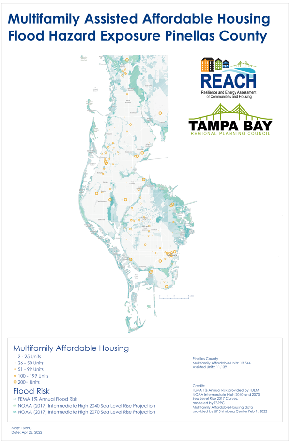
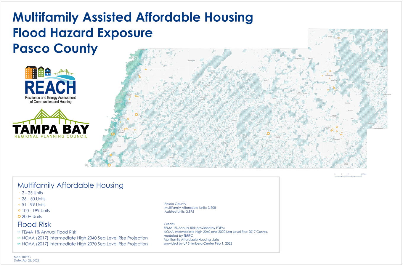
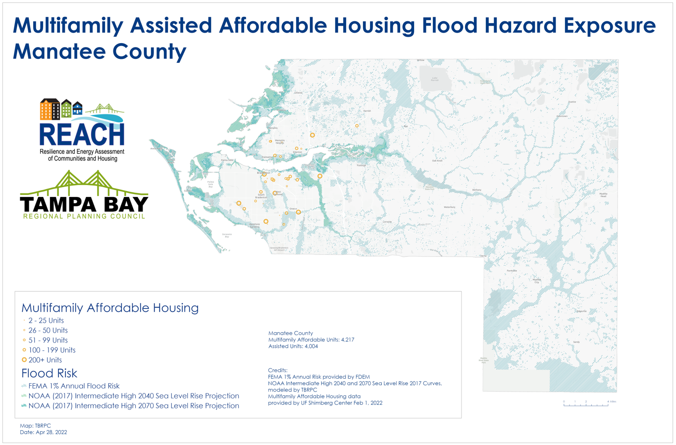
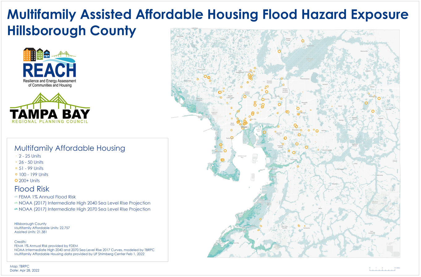
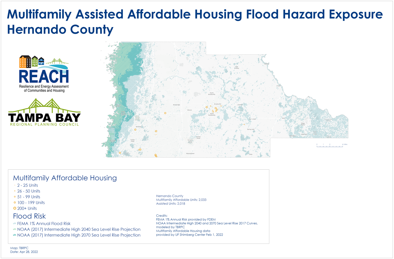
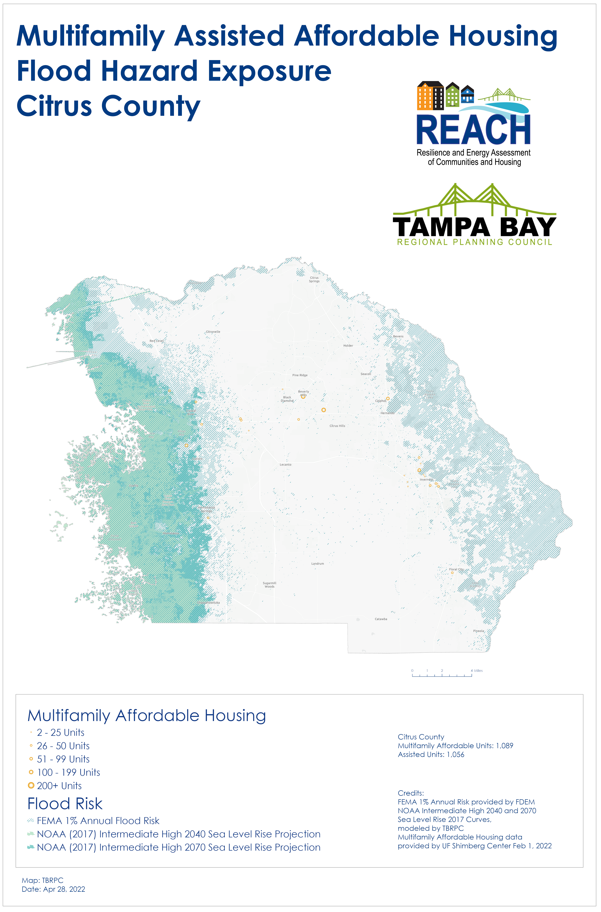
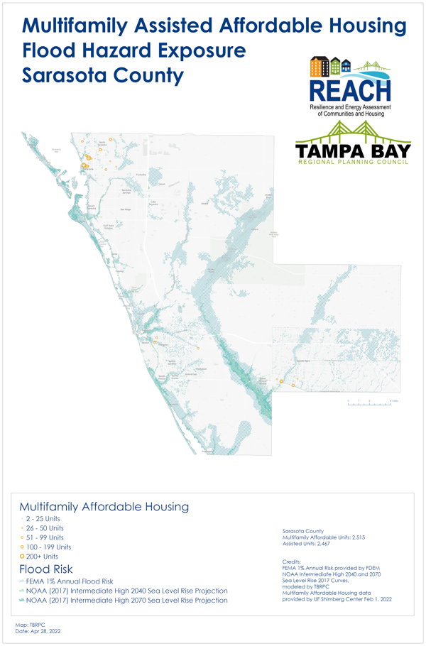
Multifamily Assisted Affordable Housing Flood Hazard Exposure Maps
HOUSING INITIATIVES
HOUSING INITIATIVES
Resilience and Energy Assessment of Housing and Communities (REACH)
The REACH Project is bringing together the region’s housing, resilience, and recovery planning experts and community leaders to assess potential risks that local communities face from extreme weather and sea level rise, and define new strategies and policies to increase affordable, resilient housing development and redevelopment. Read about REACH’s goals and partners.
TECHNICAL ASSISTANCE FOR LOCAL GOVERNMENT PLANS
TECHNICAL ASSISTANCE FOR LOCAL GOVERNMENT PLANS
The New REACH Housing and Planning Self-Assessment Checklist
In 2021, the Florida Housing Coalition and the Tampa Bay Regional Planning Council (TBRPC) introduced a new planning self-assessment checklist to support the integration of affordable housing and resilience planning. The checklist was developed with input from staff working in planning and housing in 2020.
The REACH checklist features a straightforward process for assessing local government plans from a resilient housing context. The checklist and the process enables staff to work together, or independently, to review specific plans and discuss best practices and define changes for future plan updates.
View the Self-Assessment Checklist (link).
The REACH self-assessment checklist includes 16 tabs — instructions, scoring and performance categories, and best practices for housing mitigation and principles on addressing racial equity. The checklist includes a tab for the following plans and programs:
- Comprehensive Plan
- Local Mitigation Strategy
- Local Assisted Housing Plan
- Community Rating System Plan
- Post-Disaster Redevelopment Plan
- Construction Standards
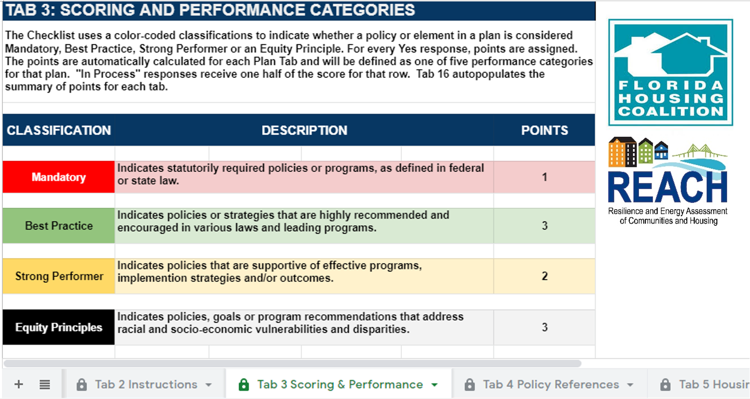
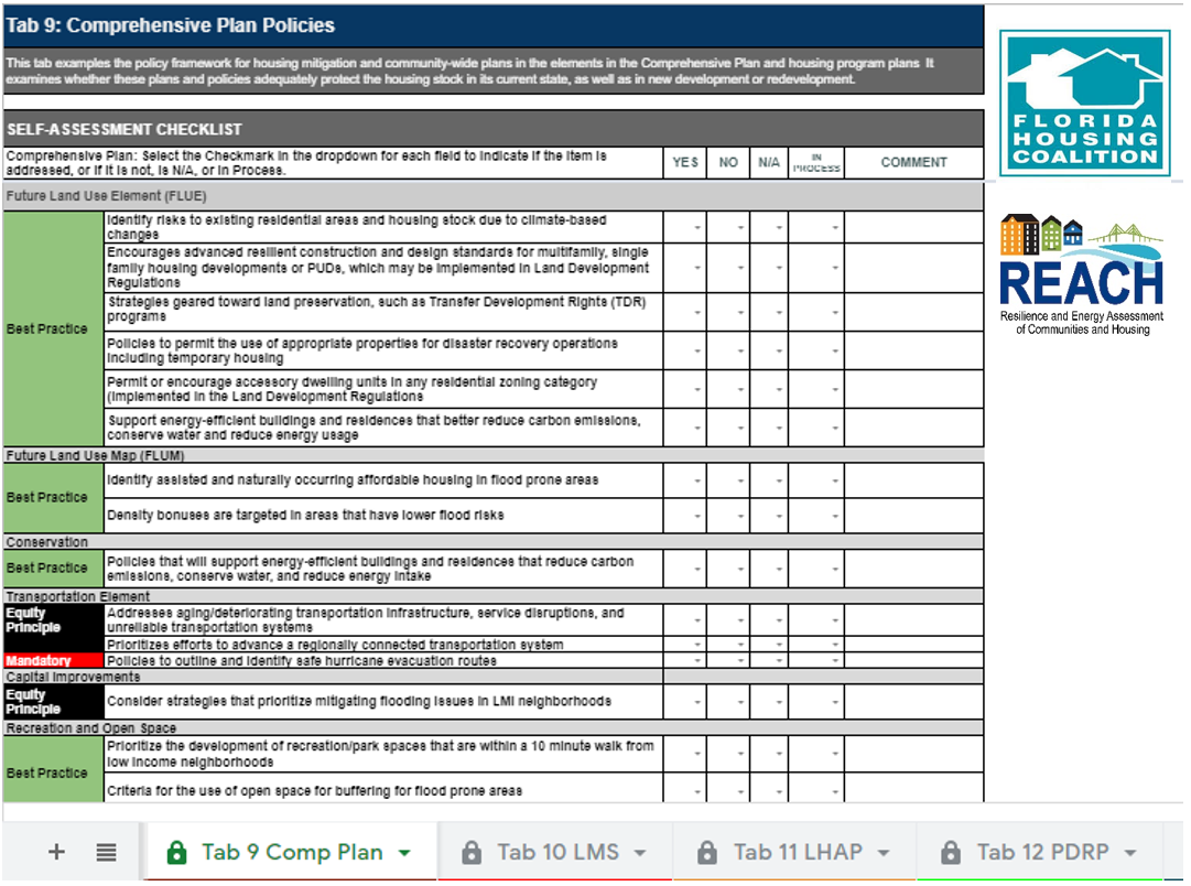
The checklist helps practitioners assess a plan’s performance by indicating whether specific goals are mandatory, or considered best practices, support equity, or are considered strong.
Housing Planning Guides – Florida Housing Coalition
The following reports are a culmination of an extensive process to develop methods and tools that evaluate local government planning frameworks for housing hazard mitigation and resilience policies to determine how vulnerable housing stock and populations are protected from probable hazards in the Tampa Bay region. Matching findings with actions, local governments have access to information about funding opportunities applicable to prioritized housing mitigation and resilience projects. Deploying data to target a community’s vulnerabilities in coordination with best mitigation practices allows local governments to practically apply mitigation best practice policies and strategies across various plans and departments and assists planners in proactively targeting investment.
FHC Methodology Report
This report describes the methodology applied to develop the Housing Resilience Plan and Policy Self-Assessment Checklist. and how the Checklist process was conducted with eleven local governments in the Tampa Bay region. Based on the findings, a list of recommendations is provided to guide local government efforts to incorporate housing hazard mitigation and resilience policy development and implementation. The Checklist is a self-assessment tool that uses an interdepartmental team approach to evaluate areas of opportunity in a local government’s plans and processes, resulting the in incorporation of consistent affordable housing hazard mitigation and resilience in policy language throughout local government planning frameworks and spending plans.
FHC REACH Methodology Report Appendix
This Appendix to the REACH Methodology Analysis Summary Report is a compilation of information including a planning framework literature review, a blank PDF of the Checklist tool, the webinar PowerPoints, and other resources to support the evaluation of planning frameworks, and implementation of housing hazard mitigation and resilience practices.
REACH Housing Mitigation Planning and Policy Framework for Florida
The REACH Housing Mitigation Planning and Policy Framework for Florida guide includes robust housing hazard mitigation and resilience policy language that local governments can use when developing policy language and incorporate into their plans. This guidance promotes consistency among plans and policies that will ensure implementation plans can better target vulnerable housing populations through implementation and spending plans and improve prioritization of housing mitigation projects when funding sources are available.
REACH Funding Guide
The REACH Funding Guide details resources available to support mitigation and resilience goals by deploying funding for evidence-based activities. Strengthening the residential housing stock and surrounding built environment in a community generates resilience in the wake of a catastrophic event. However, mitigating these risks requires access to funding resources and benefits from the support of the local, state, and federal government entities. The guide provides tips for the strategic deployment of the funding sources to maximize the potential for each source for leveraging with other sources and targeting the most vulnerable properties for mitigation activities. Many of the sources can be used for strategic planning for resilience which can be augmented by the accompanying guide, Creating a Housing Resilience Strategic Plan.
REACH Creating a Housing Resilience Strategic Plan
This REACH Guide to Creating a Housing Resilience Strategic Plan applies to municipalities as well as a regional focus. The guide combines all of the REACH tools, including: the Housing Coastal Hazard Mapping Tool, the Community Vulnerability Analysis, and the Resilience Policy Checklist. Instructions are provided to local government housing and community development, planning, emergency management, community stakeholders, and elected officials. The intention is that the policy language, goals, and objectives developed and originating in the Housing Resilience Strategic Plan can be incorporated into a community’s overall planning framework.
REACH Guide to the HUD Consolidated Plan Hazard Mitigation Element (MA-65)
The REACH Guide to the HUD Consolidated Plan Hazard Mitigation Element (MA-65) provides an overview and tips for completing the Hazard Mitigation component in the Market Analysis section of a local government’s Consolidated Plan, as required by HUD. Several samples of the MA-65 Hazard Mitigation Requirement are provided in the guide’s appendix.
REACH Energy Workshops
In April 2022, the University of South Florida FCCD+R and TBRPC held two virtual workshops to discuss energy inefficiency and energy burdens facing low income residents.
Energy Workshop #1 April 13, Defining Energy Issues and Needs
This workshop included a presentation on risks and conditions, and stakeholders shared information about current projects and issues, and the agenda item “Making the case for energy efficiency improvements and identifying roadblocks”. Watch the recorded webinar.
Energy Workshop #2 April 25, Funding and Implementation Strategies
In the second workshop, agenda items included: Retrofits for public and privately owned housing, Breakout Session: Funding and implementation, Strategies for tracking success, and Big Idea report out and suggestions for next steps.
READ the Report: USF prepared a summary report of the workshops, including case studies and recommendations for local programs.
Community Vulnerability Assessment (Coming Soon)
The REACH Community Vulnerability Assessment Guide defines a scalable vulnerability assessment process with recommendations for specific variables to improve local vulnerability and resiliency. This guidebook will provide municipalities with a consistent process to identify stressors that will negatively impact adaptive capacity and recovery.
This guidebook is a decision support tool designed to help local governments conduct exposure and sensitivity analysis focused on two major community components — people and housing.
This guide will help local governments to identify how current and future hazard risks impact;
- Social vulnerable populations;
- Current and future housing needs through mapping existing housing resources and repetitive loss properties;
- Existing affordable housing with mitigation potential; and
- Areas where new housing could be developed for long-term safety and resilience.
With this Guide, staff can support interdepartmental information sharing and resilience planning to maximize resources and provide multiple benefits. The ability for a community to prepare for stressors and shocks in advance of a threat or change and recover is its Adaptive Capacity. Expanding the adaptive capacity of communities, especially concerning affordable housing is a main goal and benefit of this Community Vulnerability Assessment Guide.
Hillsborough Case Study: In April of 2018, Hillsborough County enlisted USF’s Florida Center for Community Design and Research and the School of Public Health to work on the Hillsborough County Peril of Flood Act Matrix of Impacts Initiative, the County’s Community Vulnerability Study, and subsequent mitigation recommendations. This sequence of work was designed to inform and to satisfy requirements for the Perils of Flood Act (SB 1094) and the Local Mitigation Strategy (LMS) Chapters 3 and 4. The Hillsborough project illuminated the importance of coordinating policy efforts, timing, and content. By assessing community-wide vulnerabilities, it became clear that continuity between data sourcing and between regional municipalities would potentially streamline the process and help Tampa Bay communities quantify shared resources and challenges. Among the lessons learned throughout the Community Vulnerability Study (CVS), was to view community elements through the lens of layered data sets. Integrated data layers tell us more than one issue at a time, highlighting the compounding effects of chronic stressors and shocks.
Integrating Racial Equity and Health into Resilience Planning: New Resources
To identify leading principles for improving racial equity and health into REACH resources, the TBRPC staff conducted an analysis and compiled a list of 30+ frameworks, white papers, and reports. The new resource provides links to key documents which offer recommendations and models for how to best integrate health, equity, affordable housing and climate justice into community development and resilience planning. This resource is useful for practitioners working in community health and equity, housing and resiliency, community engagement and overall resilience planning. Review the resource (link).
In Fall of 2020, the TBRPC began a process of engaging public health experts, community health planners and a diverse list of non-profit organizations and local governments working on racial and social equity. The TBRPC coordinated a workshop in December 2020 to review and discuss local social factors, community vulnerability issues, expected impacts of extreme heat to health. This workshop helped to define priorities and goals that were included in the Regional Resilience Action Plan which will be released in late 2021. Experts from the Florida Housing Coalition, United Way Suncoast, Pinellas County Health In All Policies Initiative, and a Tarpon Springs emergency medicine specialist presented.
Watch the Regional Action Plan Equity Workshop on YouTube.
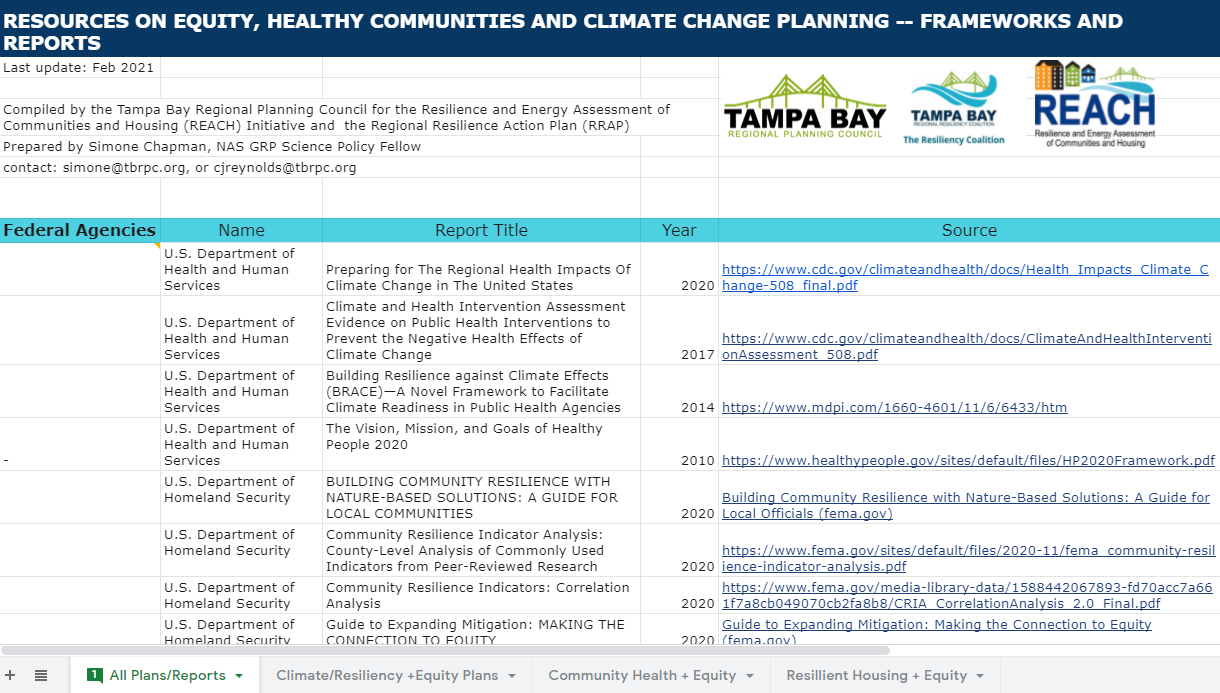
List of leading resources for improving racial and health equity in resilience planning.
HOUSING INUNDATION
ASSESSMENT TOOLS (NEW)
HOUSING INUNDATION
ASSESSMENT TOOLS (NEW)
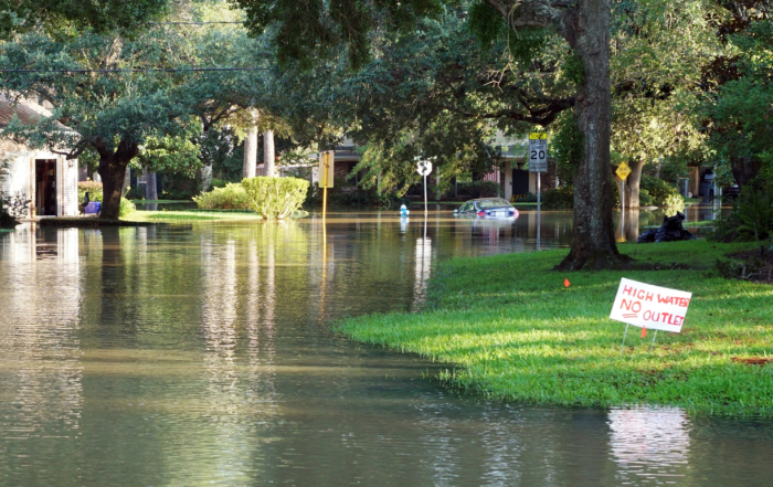
New Housing Flood Mapper and GIS Methodology Supports Consistent Data and Imagery
Accurate, transparent, reliable data are crucial to vulnerability assessments and developing plans. Establishing common criteria and using consistent symbology is needed to support public understanding and comparison across jurisdictions. The REACH project is supporting development of new tools that will enhance local government efforts to quantify current and future flood risks to housing stock. These tools and the data will lead to targeted housing rehabilitation strategies, inform construction goals and support development of land-use policies.
University of Florida Coastal Hazards Mapper
The Housing Coastal Flood Hazard Vulnerability Mapper developed by the University of Florida Shimberg Center for Housing Studies with the TBRPC is a browser-based tool for analysis and display of statewide housing susceptible to flood-related hazards.
Housing characteristics can be queried, summarized, visualized and downloaded for further analysis on the desktop. Housing data is based on the Assisted Housing Inventory (AHI), compiled by the UF Shimberg Center, and the Florida Department of Revenue parcel database (2018). The data layers include the sea level rise scenarios to support FDEP vulnerability assessments.
You can access and download the housing datain the online REACH mapper at the Data Portal to access the residential and multifamily files.
To learn about the layers, files and tips on using the mapper, download the REACH User Guide and Frequently Asked Questions.
Workshop May 26, Conducting Vulnerability Assessments for Affordable Housing
The researchers at the University of Florida Shimberg Center for Housing Studies and TBRPC released information from the new regional reports which defines risks to affordable housing in each Tampa Bay Regional Resilience Coalition. The team also provided training and tips on using the new REACH Coastal Flood Risk web mapping tool and database developed in collaboration. The new tools help local governments and organizations easily and quickly identify buildings and populations potentially impacted by hurricanes and future sea level rise.
Housing GIS Methodology
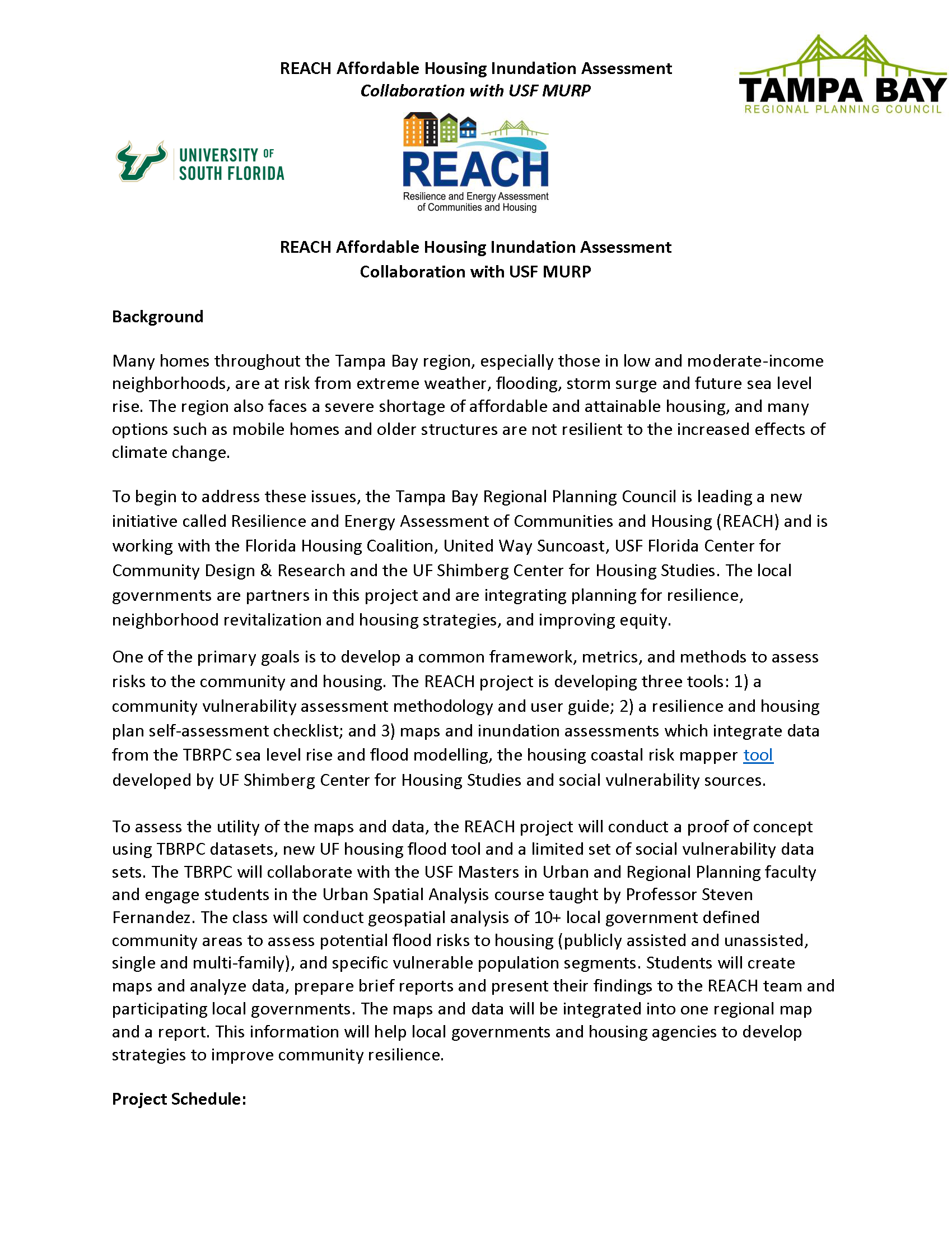
Building on key data efforts produced by the TBRPC, USF and UF, the REACH project has defined a goal of creating a consistent methodology and GIS user guide to standardize the way the region conducts housing vulnerability assessments for flood risks and future sea level rise.
In Spring 2020, the TBPRC, UF and USF Masters in Urban Planning Program faculty and researchers collaborated to develop criteria for housing and mapping symbology. The USF MURP graduate students conducted housing inundation and vulnerability analysis for 10 community areas in six counties. The initial mapping information will be reviewed and presented on May 6, 2021.
The Housing Assessment used the following data sets:
Flood Risks
- Category 1 Storm Surge (2020)
- Category 3 Storm Surge (2020)
- Evacuation Zones
- NOAA Intermediate High 2070 Sea Level Rise & Exceptional (King) Tides
Housing Factors
- Assisted multi family buildings and total units
- Unassisted multi family and single family buildings and total units
- Unassisted housing below $180,000
- Year built, construction type, funding source
- Mobile homes and mobile home parks
Social Vulnerability Data
- Age – 75 years and up
- Household Income – Area median income
- Minority Population
Download the Course Project Overview and the Mapping Symbology.
The Housing Case Studies are presented below.

HOUSING CASE STUDIES
To assess the new standardized mapping process and outputs, the REACH team selected 10 community areas in the Tampa Bay region to study the number and types of homes that are at risk of flooding. The community areas were chosen if they fit the following criteria: located within areas of future and current flood risk; the location has a high number of publicly assisted properties exposed to flooding; and if the location had an EJSCREEN Demographic Index score of 80th percentile or above (average percentile of the minority population, low income, etc). After reviewing the case study findings for each community area, one integrated report will be available.
For this case study, the inundation datasets were integrated with socioeconomic datasets, such as minority populations, household income (in relation to the Area Median Income), and Age (persons 75 and older). Research shows these are some of the top social indicators that are at higher risk of current and future flooding events. This project will help to provide answers to the following pressing questions:
- How many publicly assisted and unassisted affordable and attainable housing units are currently at flood risk now? in 2070?
- How does Year Built and Construction Type exacerbate or reduce vulnerability?
- Where would housing rehabilitation investments provide the most benefit for the greatest number of families?
On right is a map showing the locations of the 10 community areas chosen for this case study:

News & Stories
REACH Webinar: Mapper and Database Training Workshop
Register for the May 26, 2022 REACH webinar to use the new flood mapper tool, conduct targeted analysis, and download data to use in your community vulnerability assessments. The REACH team will release [...]
REACH Webinar : Mitigation and Planning for Affordable Housing
Join TBRPC and experts from the Florida Housing Coalition for a presentation and discussion about improving affordable housing disaster mitigation planning and risk reduction priorities identified by local governments. We will review and discuss [...]
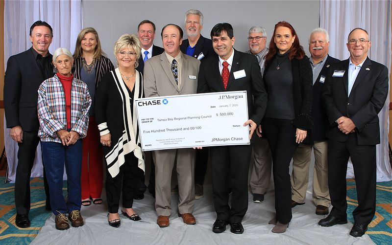
Chase grant will help Tampa Bay area make plans for more resilient affordable housing
A $500,000 grant from JPMorgan Chase to the Tampa Bay Regional Planning Council is a big first step to planning more resilient affordable housing in the region. The two-year grant program will fund the [...]