


Peril of Flood Workshops
Staff Contact
Cara Woods Serra, AICP, CFM
Principal Resiliency Planner
![]()
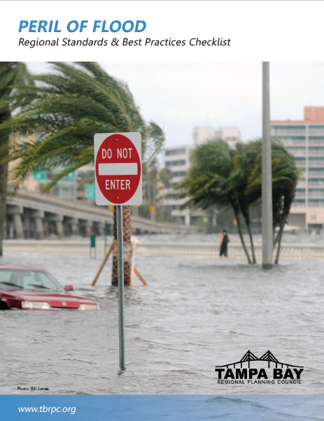
In 2015, the Florida Legislature passed Senate Bill 1094, titled “Peril of Flood”. The new law, which became effective July 1, 2015, specifies new requirements for the coastal management element of a local government’s comprehensive plan related to coastal flooding and the related impacts of sea level rise.
- Local Government Guide to Understanding the 2015 Florida Peril of Flood Act (TBRPC 2017 report)
Regional Peril of Flood Initiatives
To comply with the Peril of Flood requirements, local governments must address development and redevelopment strategies to reduce flood risk.
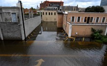
Presently, the Tampa Bay area has experienced what an acute amount of rainfall can do in terms of damage. For instance, in 2015 the area experienced 7-9 inches of rain. Hurricane Harvey also set a precedent by showing that a storm could stall and double or triple rainfall totals for an area. The likelihood of a repeat event is not that far on the horizon. Since 1946 the Tampa Bay Area has seen a mean sea level rise increase of 7.8 inches.
In 2018, the TBRPC received a grant from the Florida Resilient Coastlines Program in the Florida Coastal Office of DEP with funding from NOAA’s Florida Coastal Management Program. The TBRPC organized meetings with Community Redevelopment Agencies (CRAs) for Hillsborough County and Pinellas County to discuss resiliency for business districts and affordable housing.
A one-day workshop “Conducting Social Vulnerability Assessments” reviewed demographic factors that increase resilience vulnerability and reviewed the CDC Social Vunlerability Index tool and ESRI Community Analyst databases. Planning and housing experts from USF, UF and Manatee County presented new data and assessments of market risks and flood risks to affordable housing, and identified strategies for mapping specific aspects of community vulnerability.
Peril of Flood Products and Resources
Manatee County Climate Portal, Housing Stock Analysis and Housing Map
For the POF project, Manatee County Government GIS Analyst Lea Harper developed the Manatee Climate Portal with Sea Level Rise inundation as well as infrastructure maps. Manatee County Redevelopment Coordinator Jeffrey Ryan developed analysis of housing stock and social impacts. The new tools were presented at the Manatee County workshop in April and the TBRPC workshop in June [Download Presentation].
Mapping CRAs’ flooding and Inundation risks
The TBRPC staff mapped the location of CRAs in Hillsborough, Pinellas and Pasco counties, using modelling and data developed for the Federal Highway Administration Grant (2018-2020). The maps visualize the inundation under an integrated threat scenario. The project looked at storm surge from a Category 3 hurricane and NOAA High sea level rise projections for 2045. Additional data was developed for the Pinellas County meeting to show the current and future projected percent of wet acres in 2045.
Mapping Mobile Home Parks
Mobile homes are extremely vulnerable to winds and storm surge. TBRPC member elected officials met in April for a Round Table Discussion Hurricanes and impacts to affordable housing. TBRPC staff mapped the mobile park density in Citrus, Hernando, Hillsborough, Manatee, Pasco and Pinellas counties. The maps supported better discussion of hurricane risks, social impacts to families and land use planning and development issues.
Analysis of Affordable Housing Risks and Impacts
Bill O’Dell, Director of UF’s Shimberg Center for Housing Studies conducted an analysis of climate threats and vulnerability of affordable housing stock and prepared an extensive presentation for the workshop [Download Presentation].
Workshop: Conducting Community Vulnerability Assessments
The TBRPC held a Peril of Flood workshop on June 14, 2019 which focused on assessing community social vulnerability factors and housing stock risks and integrating into resilience assessments. The presenters included university faculty and local government staff that have conducted community vulnerability assessments for Peril of Flood projects. The workshop provided new information on social vulnerability, housing stock issues, discussed situation-specific assessment rationale and strategies, and reviewed GIS tools, maps and new visualization products.
- Peril of Flood Overview Jerry Murphy, JD, ACIP, CFM, University of Florida Resilient Communities Initiative
- Overview of United Way ALICE Hillsborough, Pinellas, Pasco, Manatee County, Douglas Griesenauer, Director of Workforce Development & Financial Stability Initiatives, United Way Suncoast
- Affordable Housing Challenges: Current and Future Impacts William O’Dell, Director, University of Florida Shimberg Center for Affordable Housing Studies
- Community Study Process Hillsborough Overview, Taryn Sabia, Ed.M., M. Arch., MUCD, Director, and and Brian Cook, ASLA, Research Assistant Professor, Florida Center for Community Design + Research at the University of South Florida
- Manatee County Housing and Social Economic Impact Assessment, Jeffrey Ryan, Redevelopment Coordinator, Manatee County Government
APA CMs were provided. Event #9178091 https://www.planning.org/cm/provider/98548/details/
Workshop #2 Updating Your Coastal Management Element — Nature-Based Tools for Flood Protection
Nature-based strategies can reduce flood risks to private and public property, support ecological systems, and identify additional opportunities for open space and recreation lands to address the anticipated changes in climate and sea-level rise over time.
On March 21, 2019, the TBBRP, in collaboration with grant partners Manatee County and the University of Florida Resilience Communities Initiative, held a workshop to support local governments. The workshop introduced key principles, requirements and strategies to successfully develop and/or update their Comprehensive Plan Coastal Elements.
Workshop Objectives:
- Understand how statutory Peril of Flood provisions relate to community planning for coastal areas;
- Understand how nature-based strategies can augment or replace conventional engineering approaches to surge mitigation and stormwater management;
- Develop a list of priority projects that consider climate change impacts (extreme weather, storm surge, sea level rise);
- Evaluate community risk reduction benefits and other ecosystem services benefits for specific projects;
- Identify local sites that are suitable for nature-based adaptation projects;
- Identify barriers in local government plans, policies and processes that need to be updated;
- Select different tools for different project phases or types.
March 21st- Tools for Nature-Based Protection Measures that Work
- Peril of Flood Provisions — Updating your Coastal Management Element, Pass the Department of Economic Opportunity review–Jerry Murphy, University of Florida Resilient Communities Initiative
- Principles of Restoration and Nature-Based Adaptation to Decrease Flood Risks– Tom Ries, ESA
- Identifying and Assessing Potential Sites– Tom Ries, ESA
- Creating Preserves: Manatee Site Case Study– Damon Moore, Manatee County
- Mapping Your Community: Coastal Resilience 2.0- Laura Geselbracht, The Nature Conservancy
APA CMs were provided: https://www.planning.org/events/eventmulti/9173770/
TBRPC conducted a series of four (4) workshops in 2017 to convene local government planners, building officials, and floodplain managers, along with stakeholders from other government agencies and the private sector. Workshop participants:
- Discussed the requirements of the Peril of Flood legislation for local government comprehensive plans
- Identified best practices to address coastal flooding and the related impacts of sea level rise
- Participated in knowledge sharing about strategies, principles, site development techniques, and related engineering solutions that will inform the goals, objectives, and policies to be developed by the local government for its coastal management element
WORKSHOPS
Presentation slides from the event are available for download. Click the “Presentation – PDF” link next to a presentation title (below) to view that speaker’s presentation slides.
Introductory Workshop #1 – Friday, March 3, 2017 – 9:30 a.m. to 11:00 a.m.
Tampa Bay Regional Planning Council, Pinellas Park
- Workshop Agenda
- Peril of Flood Act Overview and Examples of Proposed/Adopted Peril of Flood-related Amendments – Mr. Brady Smith, AICP, CFM, Tampa Bay Regional Planning Council
- City of Tampa 2015 Peril of Flood Act Vulnerability Assessment – Mr. Shawn College, AICP, Hillsborough County City County Planning Commission
Introductory Workshop #2 – Monday, March 27, 2017 – 1:30 p.m. to 3:00 p.m.
Southwest Florida Water Management District, Brooksville
- Workshop Agenda
- Peril of Flood Act Overview and Examples of Proposed/Adopted Peril of Flood-related Amendments – Mr. Brady Smith, AICP, CFM, Tampa Bay Regional Planning Council
- City of Tampa 2015 Peril of Flood Act Vulnerability Assessment – Mr. Shawn College, AICP, Hillsborough County City County Planning Commission
Workshop #3 (Webinar) – Friday, March 31, 2017 – 10:00 a.m. to 11:00 a.m.
- Workshop Agenda
- Webinar Presentation Slides (PDF)
- Webinar Video Recording (WMV) – Heidi Stiller’s Demo of the NOAA Sea Level Rise Viewer and Coastal Flood Exposure Tool begins around the 19:30 mark of the video
Workshop #4 – Friday, May 5, 2017 – 9:30 a.m. to 11:00 a.m.
Tampa Bay Regional Planning Council, Pinellas Park
2018-2019 PROJECT OVERVIEW
The 2018-2019 Peril of Flood Project is supported by a grant from the Florida Resilient Coastlines Program, in the Florida Coastal Office of DEP with funding from NOAA’s Florida Coastal Management Program. The TBRPC project focuses on addressing the requirements of the Peril of Flood legislation through a two-pronged-approach which seeks to integrate “nature-based” adaptation, and affordable housing and social resiliency.
Local governments are in the process of identifying areas that are vulnerable to coastal flooding, and can become more resilient by using environmentally-based adaptation techniques and green infrastructure projects to reduce localized flooding issues. Using environmentally-based resiliency approaches, such as restoring wetlands and re-naturalizing shorelines or preserving open spaces can provide buffering from storm surge and flood reduction benefits. Identifying vulnerable areas can, in turn, provide the data and illustrative mapping to support policies, principles, and strategies to inform comprehensive plans, especially coastal management elements and required redevelopment components to enhance future resiliency.
Integration of social vulnerability and social equity issues associated with future climate risks and certain housing segments and populations, currently lags behind knowledge of the vulnerabilities of infrastructure and the built environment. Increasing the communities’ and region’s understanding of social vulnerability and use of planning equity principles will help prevent unintended consequences from maladaptive development and redevelopment.
To support this, the project team is convening experts to discuss and develop a process and strategies that will enable local governments to integrate social vulnerability aspects and long-term impacts of low-income housing, public housing, Community Redevelopment Areas, and discuss inclusionary planning processes and collaboration with non-profit agencies and organizations that oversee a range of service delivery systems.
The Peril of Flood Project activities include:
- Implementing a Plan Status and Training Needs Survey
- Development of Integrated Vulnerability Assessment Best Practices Checklist
- Technical Assistance Workshops
- Nature Based Adaptation March 21
- Increasing Community Resilience Manatee County Workshop, April 30
- Integrating Social Vulnerability Into SLR Assessments and Mapping, June 14
- Community Redevelopment Areas, June 11-12
- Final Project Report
2018-2019 PROJECT TEAM
![]()
Tampa Bay Regional Planning Council
![]()
![]()
University of Florida Resilient Communities Initiative

University of South Florida College of Marine Science and the USF Department of Urban Planning
Peril of Flood Florida Statute SB 1094
“Each must contain a coastal redevelopment component that addresses how to eliminate inappropriate and unsafe development in the coastal areas when opportunities arise redevelopment component must now:
- “Include development and redevelopment principles, strategies, and engineering solutions that reduce flood risk in coastal areas which results from high-tide events, storm surge, flash floods, stormwater runoff, and the related impacts of sea-level rise.
- “Encourage the use of best practices development and redevelopment principles, strategies, and engineering solutions that will result in the removal of coastal real property from flood zone designations established by the Federal Emergency Management Agency.
- “Identify site development techniques and best practices that may reduce losses due to flooding and claims made under flood insurance policies issued in this state.
- “Be consistent with, or more stringent than, the flood-resistant construction requirements in the Florida Building Code and applicable flood plain management regulations set forth in 44 C.F.R. part 60.
- “Require that any construction activities seaward of the coastal construction control lines established pursuant to s. 161.053 be consistent with chapter 161.
- “Encourage local governments to participate in the National Flood Insurance Program Community Rating System administered by the Federal Emergency Management Agency to achieve flood insurance premium discounts for their residents.”